|
 |
Horizon Mapping
Farmers' Voice: Bangladesh Map Galleries
|
| |

|
Chalan Beel Wetland
|
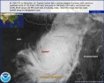
| Cyclone Sidr - November, 2007 |
|
Cyclone Sidr roared in from the Bay
of Bengal Thursday, November 16th, 2007, and struck Bangladesh with 240 kph
(150 mph) winds and a 10-20 foot storm surge. The catastrophe is responsible
for overwelming human loss as well as untold destruction of unique natual
environments.
Click here or on Map for Slide Show
|
| Country Atlas |
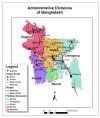 |
Bangladesh is a country in Southern Asia, bordering the
Bay of Bengal, between Myanmar and India. 150 million people live within its
144,000 sq km of mostly low lying coastal lands. The climate is tropical,
making the vegetation luxuriant and the country takes pride in hosting
the Sundarbans, the largest littoral mangrove forest.
Click here or on Map for Slide Show
|
| Environment |
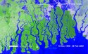 |
The environment of Bangladesh supports a wealth of
biodiversity, including 113 species of mammals, 628 species of birds and
126 species of reptiles. Many of these species are of international significance,
such as the Asian Elephant, Royal Bengal Tiger, Gharial, Gangetic Dolphin and
Hoolock Gibbon.
Click here or on Map for Slide Show
|
| Wetlands |
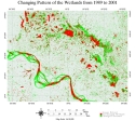 |
Wetlands play key roles in the environment, providing habitat for wildlife
and native plant species, supporting biodiversity, alleviating flood conditions, and eliminating
pollutants from the water supply. They are also very sensitive to environmental conditions,
including sedimentation, storm surge and climate change. The low-lying coastal lands of
Bangladesh provide optimal wetland potential, but are vulnerable to detrimental
environmental impacts.
Click here or on Map for Slide Show
|
|
|
|